The day before the race, we drove 6 hours from NH to Van Buren, Maine and spent the night within sight of Canada, just this side of the St. John River. In the AM we crossed the border into Saint Leonard, NB, grabbed some provisions in town and drove through southern NB to Mount Carleton Provincial Park. Although we weren't very far from home, the predominantly French-speaking Western NB culture provided an international feel.
Arrival at the park several hours before start time gave us plenty of time to register, gear up, meet with race director Troy Johnston and plan our routes and strategize over the map. An interesting wrinkle we discovered at this time was that the 40-hour and 24-hour courses were the same. For the 40, the strategy was straightforward: get through all the CPs as fast as you can. For the 24, it was a little more challenging because you did not have time to hit all the CPs, so deciding which optional CPs (if any) to go after while still leaving yourself enough time to clear the mandatory points in 24 hours was the tricky part. Below is a video of Rob doing some pre-race planning while we wait out some rain in the car.
We got a nice thunderstorm (there were lots of these throughout our Canadian visit) for the hours before the race, so we started the race on our bikes with rain jackets at 4:00 PM. 5 minutes later the sun was beating down on us as we rode the first leg and the jackets quickly came off.
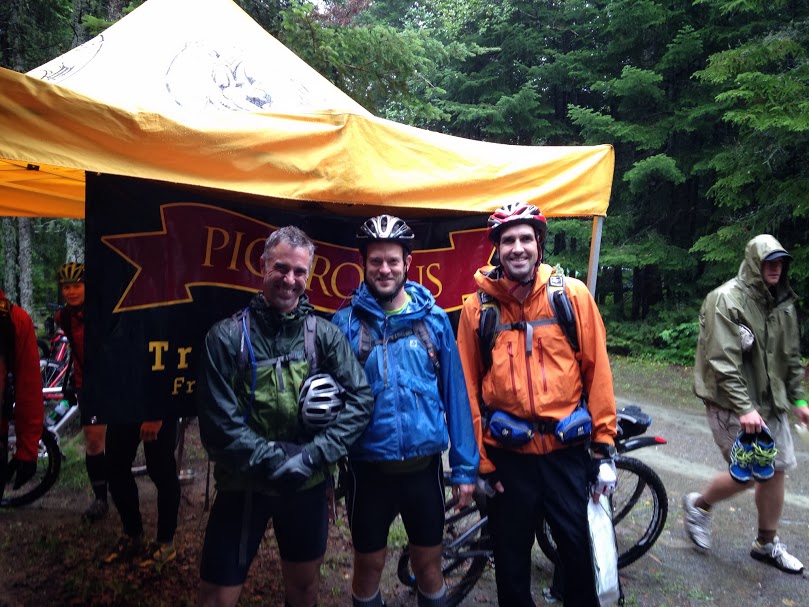 |
| A few minutes pre-race. Picaroons (the banner in the background) is a local brewery and race sponsor! Photo:NSAR |
The bike legs of this race were on logging roads of various age and use levels. Most were easily rideable. Surprisingly, most of these were indicated on the 1:50,000 master race map, since the race organizers obtained a logging road layer from the timber company to add to the dated info on the topo maps. Navigating this labyrinthine dirt road network would have been a very tough without that layer.
We saw a bear and a moose on bike legs during the race. Both were sighted shortly after we had gone off course. We theorized that they were some kind of AR spirit animals sent to lead us back to the right path.
The first bike leg contained 2 CPs and was about 30-35 km in length. We cleared this section fairly easily except for an initial screwup, which is the normal NH TrailVets method. Basically all of the CPs on the bike leg were off the road, in or around water. The bike shoes were saturated with pond/swamp water and mud pretty much the whole time.
Following this first bike leg was the first trek leg, which would involve following some logging roads and a fairly short bushwhack. We were trying to hurry as much as possible, because dusk was approaching and the next leg was the paddle. Trying to navigate the paddle after dark would really slow us down, so we wanted to get to the next TA ASAP. The bushwhack took us to a pretty serious stream/river (lots of rain lately) but luckily Rob spied a sturdy log we could cross and avoid a river ford. A little more trail and then a bushwhack to CP 3 which was on a beaver hut at the edge of a swampy pond. The swampy pond seems to be a favorite feature of Bruno, the course designer! As Rob stepped to the edge of a small stream to punch the CP, Nick and Mason heard a yelp and hurried over to find Rob (who is 6'2") waist deep in muck. We then found some roads down to TA2 on the banks of Branch Reservoir. We passed several interesting mini-snowdrifts along the way from a recent hailstorm.
We arrived at TA2, excited to have at least an hour of daylight ahead of us in which to paddle our canoe. We transitioned as quickly as possible and paddled 3.5 km to CP4, following that was a 6.5 km paddle to CP5 as the sky darkened. Sunset over the Branch Reservoir was nice - not a house or artifical light in sight, just us, the loons and one other team far away from us. It was full-on night when we reached CP5, but we could make out just enough to guide ourselves back to the TA while covering another 7 km. We were shivering uncontrollably at the TA, presumably from being cold and wet for so long, so we took some extra time to layer up and eat before heading off on foot for the next leg.
 |
| Sunset paddle |
After a couple km on logging roads, we had to bushwhack some more to find CP 6, which we eventually did, after following a stream through some very tight woods (very reminiscent of CP 14 at Untamed 2013). We then had a 1 km bushwhack back to trail, involving dense woods, lots of raspberry brambles and some less-painful mixed conifer/weedy areas.
After a couple more km on dirt road, we decided to quickly grab an optional CP (4) on a nearby stream (again the water theme) before checking back in to grab our bikes at TA4. This was probably our longest TA, as we took time to add some dry clothes for the bike section, get some decent caloric intake, refill water, and double-check the route. Nick determined that his chicken patties actually were not pre-cooked after an initial bite and wisely found other nourishment.
 |
| At TA4 |
Next was the 2nd bike leg which would take us to 3 CPs over another ~45km, ending at TA5. The leg began with a steep little 250 ft climb and then leveled off as we rode to CP7 on the shore of a ...swampy pond. Finding this was one of the 2 significant nav errors we made in the race. The pond looked to be an easy find off the end of a nearby road and we overconfidently and stupidly left the map on the bike as we bushwhacked to it. We eventually found the pond, surrounding by some cool floating grass rafts, but we had arrived there pretty circuitously. Without the map, we were unable to navigate back to where we had dropped our bikes at the end of the road and had to make our way south for a while to a catch feature road and walk 10 minutes back to our bikes. We then had a long ride to CP8 which was on what used to be a logging road, but some time ago had been blocked off by the damming action of beavers and a large muddy beaver pond stood in the way. This was an unwieldy muddy awkward night bikewhack across the dam to the other side, but the CP was easily found once we crossed over.
 |
| Not our picture, but I think this is the beaver pond. We crossed at night and decided to walk on the dam to the left rather than through the muddy pond itself, like this fellow. Photo credit: Team Rocket Goat! |
After the beaver pond was the only stretch of singletrack riding in the race. We were then faced with a navigational challenge as dawn broke. The road system we were going to follow to CP9 had been wiped away by a recent clearcut and a couple new roads. We futzed around for a few minutes and were not able to find any easy way to get to the road we needed to reach, so we just started south, initially on a muddy skid track and then for a long slow bikewhack through a riparian tangle to Mamozekel River. We walked up the river for a little bit and then found tracks on the other side of the river and crossed over in waist deep, briskly moving water carrying our bikes to the slightly less tangled terrain on the other side. A little more faster bikewhacking and we had gained our target, the road to CP9. We were not highly successful in this navigational challenge and lost considerable time, allowing the race leaders (The Rocket Scientists, who had grabbed a few more optional CPs than us) to catch up.
The six of us rode together to the easily found CP9. We then headed uphill to find TA5 and they stayed behind to grab one more optional CP before following us. This gave us a bit of hope: we weren't going to beat The Rocket Scientists on points but there was a lot of race left and only another 6.5 hours to get it done. If they were unable to get all the mandatory CPs and reach the finish line before 4:00 PM they would be DQ'd and we would win.
After biking up to TA5 (and seeing our spirit moose along the way). We dropped our bikes and geared up for the final trek. There was a little food at this TA - cold franks and beans and mac&cheese with franks which was just delicious to us at this point. We also each guzzled a Coke from the cooler at the TA (thanks!) and then we were off. This trekking leg was wholly within Mount Carleton Provincial Park and consisted of 4 mountaintop CPs (Mounts Carleton, Head, Sagamook and Bailey). We were following trail for this part, no bushwhacking or difficult navigation - just hustling as fast as we could muster. I count a total elevation gain of about 2750 feet on this leg.
The challenging aspects of this leg were trying to move as fast as possible on the wet rocky trails and navigating a painful steep descent between Mts. Sagamook and Bailey. Rob also burned through his energy reserves scaling to the top of a false summit on Mt Bailey, and then had to rally as we felt a need to run the last miles to ensure finishing before the time cutoff.
We reached the finish line with a full hour to spare, only to be greeted by Troy who informed us "There's one more checkpoint". The moment of panic quickly passed, however as we learned the details - a dip in Lake Nictau, a short swim and grabbing a mystery item out of a bag on the lake bottom. A cooling rainshower (surprise.) had just passed through the area and no one was relishing a brisk swim but it did feel good to rinse off the trail grime in the refreshing lake and the mystery item provided some well-needed refreshment at the end of the race.
Our slim chance of victory vanished as The Rocket Scientists emerged from the woods, only about 10 minutes behind us. They had a great race and may have been the fastest team on the course - they finished in about 23 hours and only skipped 2 CPs off the full course. The overall race winner (winner of 40 hour division) was Untamed Canada, who adeptly cleared the whole course in about 29 hours. We were happy with our 2nd place finish and enjoyed some cameraderie, delicious barbecue and Picaroons beer at the post race shindig before sleepily heading back toward home. Nick had to be at work in Portsmouth in the morning :( while Rob and Mason crashed overnight in nearby Saint Quentin.
A huge thanks to the whole of the Natural Selection AR crew as well as all the sponsors and other competitors. We had a blast and definitely plan to be back for more north-of-border adventuring.
 |
| Mason after punching CP 10 atop the foggy summit of Mt Carleton |
 |
| We encountered this partridge on these trails |
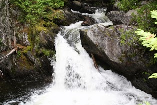 |
| We passed by these falls too. Gorgeous stream, but the trail was about as steep as the streambed - no fun to descend on worked-over legs. Photo: NSAR |
 |
| Team photo post-swim. Photo:NSAR |
A huge thanks to the whole of the Natural Selection AR crew as well as all the sponsors and other competitors. We had a blast and definitely plan to be back for more north-of-border adventuring.
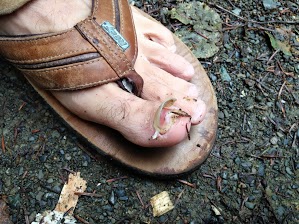 |
| Rob's vertical toenail post-race. Eww. |
Beaver pond photo credit: Jonathan Millar - Team Rocket Goat.
ReplyDeleteThanks!
Delete